Cycling Southampton to London (the scenic route)
Cycling has always given me such a sense of freedom. The self-satisfaction that comes from completing a journey powered entirely by my own energy is irrepressible. A short daily commute by bike in all weathers makes for a heady combination of endorphins and smugness, which, I am assured, endears me to my colleagues.
Regrettably, I haven't recently found the time to get out on a longer ride. Facebook's algorithms are exquisitely designed to bring me the braying of friends having completed half-marathons, marathons, ultra-marathons and, since the Tour de France, multiple laps of the country by bicycle. Using the (very long) lever of social networking peer pressure, I lifted myself out of the rut. The idea of cycling from my house in Southampton to London had captivated me. Partly this was because it provided a known quantity - being a journey I often make by train - partly because the distance - around 90 miles - was achievable within a day, despite being over double the length of any ride I had previously made.
I had heard of the British Heart Foundation's London to Southampton ride, but sadly this was not scheduled to take place again in 2014. The idea of a guided route was attractive, but I manufactured my own guide in the form of an Android phone tucked into the map pocket of my cycle bag and the excellent OSMAnd. This app can be configured to show the Open Cycle Map, displaying national, regional and local cycle routes, and to provide GPS-style navigation. With voice-only GPS, I found I attracted some odd looks but was able to navigate in all but the busiest/noisiest places.
Rather than use OSMAnd's built-in route finding, I chose to use BRouter to get greater control over the route. BRouter is the best online cycle routing tool I have found that balances automated route calculation with manual configuration. Using the default 'trekking' profile, the routing algorithm prioritises cycle routes over roads where possible. However, for the geekier among us, it also allows complete tailoring of the profile, which means you can customise the route entirely according to your preferences for track type. The route can be exported as GPX and loaded into a Garmin or, in my case, into OSMAnd.

I opted for the default route with a few manual tweaks. This route sent me out of Southampton to Winchester and along national route 23. This was an excellent start to the journey and was a quiet but fast run through some beautiful countryside and villages. Route 23 ends abruptly at Holybourne, at which point dead reckoning led me to join route 22 at Farnham. Things got a little weird in Farnham, as I departed briefly from the 22 to 'enjoy' a trip through a local retail park. This, I discovered, is the peril of GPS-led navigation.
The route departed again from the 22 to head north along Blackwater Valley and Basingstoke Canal. This turned out to be a mistake, as the route was favourable principally to walkers and proved to be muddy and narrow in places. East of Frimley, route 221 follows the canal path for a time, but the route only transforms into a respectable cycle track east of Woking. In hindsight, I should have stayed on the 22 until Guildford and taken the 223 north instead.

Never have I been so pleased to see the M25, signifying that central London was at last within sight. Heading north along the River Wey, I joined route 4 and travelled along the River Thames. This was a stately way to proceed into the capital, offering fine views of the leafy suburbs and plenty of opportunity to stop at one of the river-side establishments.
Skirting around Hampton Court Palace, my route diverged from national route 4 in favour of a more direct line into south London along the A3. While offering a cycle route, the views were far from edifying and I suspect continuing along the 4 would have been preferable. Nevertheless, I reached Clapham Junction and, after a brief pit-stop, blazed a trail up Clapham Road, past the Oval, to my destination in Kennington. This last section was courtesy of CS7, one of London's commuter "super highways". Apparently sponsored by Barclays, the CS routes are marked in blue and take cyclists from the outskirts right into the heart of London. The route was well segregated from car traffic, but shared the bus lane for much of the distance. Despite this, cycling felt safer than I had expected in London.
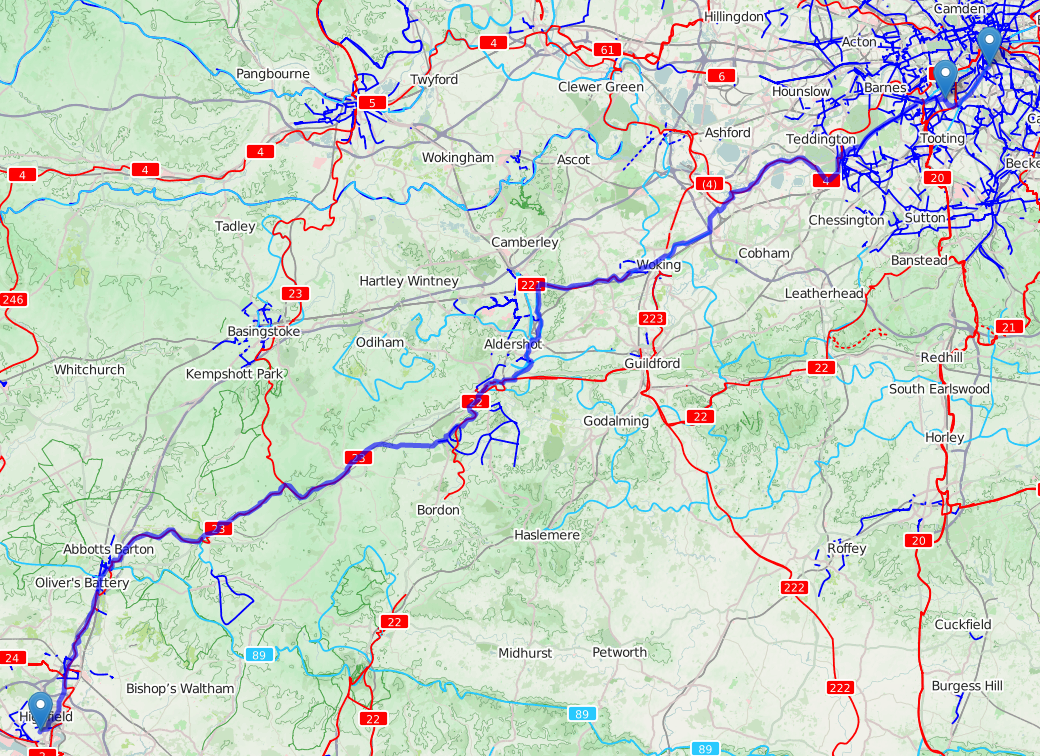
The route was 90 miles in total and took around 8 hours, averaging about 11mph. The faster sections were by far the quiet country lanes, while the canal and river paths brought my average speed down a great deal. If I were to attempt the journey again, I would try BHF's route, which can be downloaded as a GPX file.
No comments:
Post a Comment